Leigh Youngblood darts off across northern Franklin County. And I struggle to follow.
Tully Road in Orange. Athol Road in Warwick. Our scenic driving route meanders through forests of hemlock, past the gladed slopes of rounded mountains, by woodland ponds and the rivers that both feed and flow from them. Turning suddenly off the pavement, I downshift onto a dirt road as we make our way through an unkempt field to the humbly unimpressive trailhead of Tully Mountain, one of several undiscovered gems lurking just around the bend.
“It’s just 20 minutes to the top,” Youngblood tells me. “You won’t find a more rewarding short hike,” she adds, referring to the summit’s spectacular view. I quickly snap a photo or two, then jump back in my car as we continue motoring along, back along the smooth blacktop country roads.
Through the small village (or was it just an intersection?) of Blissville. Past Bliss Hill Road and nearby Bliss Hill. Thirty miles an hour, giving way to 40, to 50 and beyond. And it is blissful. Spending time on a beautiful early autumn afternoon speeding through a portion of our state, our Valley, our world, which through no fault of its own seems vastly underappreciated.
The car struggles to hold the turns of the road as I struggle to keep my focus on the driving, downshifting to fourth gear as the road climbs another embankment, then returning it to its faster fifth gear as the route momentarily flattens and Youngblood continues purposefully toward our next stop. It’s impossible to keep from glancing off to the side of the road at the inviting dirt paths, logging trails and canopied forest floor that invite easy exploration.
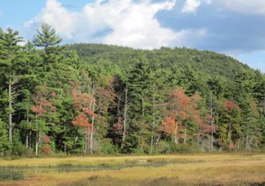
Youngblood taps her brakes and turns onto another dirt road, momentarily parking on its side, where we are afforded a nice view of Mount Grace, the mountain for which the Mount Grace Conservation Land Trust, the organization of which Youngblood is executive director, is named.
Begun in 1986, Mount Grace Conservation Land Trust was founded to conserve farmland and forestland in the north and central region of the Bay State. Since then, it has been involved in some 200 varied projects which have preserved over 26,000 acres of land. While the Trust’s acquisitions vary in size and purpose, they are all part of a vision in which “the rural landscapes and natural resources of north central and western Massachusetts [are] preserved, so that all may enjoy and appreciate these lands,” as its website (mountgrace.org) says.
The effort is exercised across a wide area, from the Quabbin Reservoir and New Salem north to Ashburnham and along the Massachusetts-New Hampshire border to Leyden. Sometimes the Trust’s staff raise funds and purchase land. Other times they help facilitate the protection of land, sometimes by dealing with two or more separate owners.
Youngblood refers to a report called Wildlands And Woodlands, which notes that the Commonwealth of Massachusetts includes approximately 5 million acres, 1 million of which are developed and 1 million of which are conserved. The report suggests that in order to have an effectively sustainable future with usable farmland, access to clean air and water and open spaces for wildlife, half of the remaining 3 million acres must be protected from unmitigated development.
Mount Grace Trust routinely engages in “landscape scale conservation,” Youngblood tells me, which employs a “multi-parcel approach that conserves an ecological system such as a watershed, or ridge, or economically-linked farms.” Typical of the Trust’s work was the acquisition of land a Winchendon woman had long held off selling because it included a northern Atlantic white cedar swamp, one of only two such examples of that natural tree community in the state. From the same owner the Trust acquired land at the headwaters of Rich Brook, a tributary of the Millers River, then transferred both parcels to the state Department of Fish and Game. Tracts held by the Trust are home to moose, bear, bobcat, beaver and otter, as well as raptors and inland forest songbirds.
One of the ways the Trust builds support is “through recreation,” Youngblood says. Included in the regions it aims to protect are several outdoor recreation spots such as the Skyfields Arboretum and Willis Woods Loop Trail at the Mount Grace headquarters in Athol, as well as Hidden Valley Memorial Forest in Wendell and the Mount Jefferson Conservation Area in Hubbardston, all of which are described in its guidebook, Twenty Years, Twenty Hikes. (A PDF version of the book, Youngblood tells me, will soon be available as a free download. For now, though, the guidebook can be purchased via the Mount Grace website.)
This afternoon, we are covering only the relatively modest route from Athol to Northfield. “It’s just over 20 minutes away,” Youngblood says of Crag Mountain in Northfield as we talk in her office at Mount Grace’s headquarters. Our caravan to Northfield, however, takes at least a half an hour because Youngblood continually adds impromptu stops to our tour of Mount Grace’s many conservation spots—all of them picturesque and worthy of note.
Eventually we arrive at our Northfield destination, after passing Old Turnpike and Old Wendell roads, and driving up another sharp incline which quickly—and not surprisingly given the tenor of our tour—takes us to yet another dirt road. This road appears to have previously been washed out at the bend by the red Stratton Lodge (with its sign dating construction to 1891); it grows smaller as the route slinks through forests of beech, sugar maple and hemlock along turns that get tighter and tighter, until finally we arrive at an industrial clearing with a swath of high retention wires. We park our cars unceremoniously at the end of the dirt path, where a sign on a tree indicates our arrival at a spot along the New England National Scenic Trail.
This trail was created by connecting the Metacomet-Monadnock (M-M) Trail, which stretches from our southern border here in the Pioneer Valley to the summit of Mount Monadnock and, to the south, meets the Mattabesett Trail in Connecticut, which runs farther south to Long Island Sound. Its promoters are hopeful that the ambitiously named New England Scenic Trail will indeed one day run across the breadth of the New England states. For now, however, it is a southern New England success only—but serves those of us in Western Massachusetts quite well.
The spot to which Youngblood has brought me is an intriguing one in the outdoor recreation landscape. It is located on a popular local trail (the M-M Trail), which is being transformed into a multi-state through trail (the New England Trail) just north of Crag Mountain, and affords excellent views to the east (Mount Monadnock and Mount Wachusett) and west (the Connecticut River and the Berkshires). On the trail stands a privately owned cabin that is available to the public for overnight visits, free of charge. “Mount Grace facilitated the forest legacy conservation restriction (CR) that allowed for the cabin to be built,” Youngblood explains.
The cabin is an accessible 10-minute walk from our parking space. There is a sink in the back, a porta-potty at the edge of a clearing, and a big fire pit. The cabin is available on a first-come, first-serve basis by calling its owner, whose phone number is posted on the door. According to its logbook, which sits in a small cabinet next to the door on the cabin’s south wall, no one had stayed there in nearly three weeks by the time we ventured there.
Walking along the M-M Trail for a bit, listening to Youngblood share information about the Mount Grace organization and their conservation spots, I suddenly felt that there were so many more hiking areas than I’d known of before. And there couldn’t be a better season for exploring trails in the Valley than autumn.