Some of the Outer Belt with its sidewalks highlighted, from a PVPC traffic study.
Springfield Mayor Charles Ryan‘s office announced yesterday that the Massachusetts Highway Department awarded $2 million for the design and construction of a traffic safety project in the Outer Belt neighborhood.
 A meeting tonight at 7:00 pm, taking place at the Christian Life Center Fellowship Hall, will provide a chance for the city’s Department of Public Works and consultant Purcell Associates to share details about the proposed project and garner some public input from Outer Belt businesses and residents.
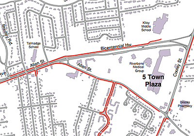
The project is focused on transportation improvements in the vicinity of Bradley Road, Allen Street, and Bicentennial Highway. This sector of the city lies east of Sumner Avenue’s end in East Forest Park at Gus and Paul’s. Included in the area: a few health care facilities, a bank or two, a few gas stations, Better Life Natural Foods, a Big Y and an incoming Stop & Shop, a McDonald’s, a Wendy’s, a Burger King, a couple of public schools, and of course a lot of residents, just to name a few stakeholders. In other words, this area is a major civic and economic hub, but its built environment makes it appear as though it’s in denial, and wants to be a fringe suburban spot.
Transportation improvements will likely include "intersection upgrades and realignment, signalization improvements, turning improvements, pedestrian improvements, streetscape upgrades and access management," the mayor’s office said in a press release.
The Pioneer Valley Planning Commission undertook a traffic study (PDF) released in 2003 that focused on this area and included resident input. In an August 28, 2002 article by Peter Goonan in the Union-News, PVPC planner Gary Roux was cited as describing recommendations like "improving the timing at certain traffic signals, constructing sidewalks and pedestrian crosswalks in key areas, and improving the traffic signs and left turn lanes at key intersections." More from that article:
Roux and city planners told residents the study will result in numerous short-term and long-term recommendations for improving traffic flow and safety, but solutions will be hard to come by. There are design challenges and very tight state and federal funding to overcome, Roux said.
"Unfortunately, the study should have been done 20 years ago," [Outer Belt Civic Association president Walter] Gould said.

A sampling of "existing deficiencies" identified by the PVPC.
Some things take time. An April 15, 2002 Union-News article by Alicia Guide brought initial focus to the challenges:
The planning commission found that there have been several crashes at Allen and Cooley streets, but the accidents did not often involve vehicles which were simply driving through the intersection. "It’s more from the vehicles entering and exiting those four sites, the four gas stations that are there," [Gary] Roux said.
The data collection also showed that there is traffic created by vehicles coming and going from Five Town Plaza on Cooley Street, and congestion at Allen and Cooley streets, Allen Street at Bicentennial Highway, and Bradley Road at Allen Street, Roux said.
A follow-up April 19 article by Bea O’Quinn Dewberry described the problem further still:
[Outer Belt resident Mary Dionne] said businesses along the Outer Belt corridor and commuter traffic from Hampden, East Longmeadow, Longmeadow, Enfield and Somers have gotten out of control. …[T]he accident rate from 1998 to 2000 showed an average of 15 accidents per year at the Allen and Cooley intersection. …


One of the short-term solutions is to improve road-lane markings and signs, cutting back landscaping along Bicentennial Highway and removing the cobblestone turning lane at Allen and Cooley intersection, [Gary] Roux said. …[Planners] have cited traffic jams, speeding, vehicular accidents and the safety of pedestrians, especially children, who walk to Marcus M. [sic] Kiley Middle School and Arthur T. Talmadge Elementary School.