Springfield’s School Committee recently updated its boundary plan, which is part of a phased effort to reduce busing (and its related cost) across the city, generate greater certainty about school assignments, increase parental involvement and student attendance, and decrease the number of schools that are not in compliance with racial balance targets. A recent report shows that some of these goals are gradually being met after the boundary plan was implemented in the 2005-2006 school year. According to the report:
Transportation cost: So far, annual savings are over $2 million. Once the boundary plan is fully implemented, annual savings are anticipated to be closer to $4 million. What these numbers include is not broken down in the report, but it does say that the changes in high school hours for the current school year "eliminated the ability to triple-tier many bus routes," leading to an expense of $1.2 million this year out of an estimated $6.4 million for 2006-2007 for 120 buses. The "ride-eligible" population is down from 75 percent in 2004-2005, when 157 school buses were used, to an estimated 25 percent in 2007-2008, with a fleet of between 70 and 80 buses at a net cost of $3.5 to $4 million. This would meet the ride-eligible population goal, the report states.
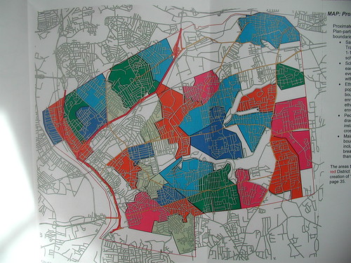
Middle school "proximate zone" and "ridership area" composite map
School assignment certainty: Under the new plan, "each address in the city has one and only one absolutely certain school association for each grade segment" for elementary and middle schools.
Involvement and attendance: Principals have reported increased involvement since the boundary plan was implemented, but no figures are supplied on this factor. Attendance has improved each year, which presumably can be proven with data but it’s not in the report.
Racial balance: In 2004-2005, nine schools were out of compliance. In 2007-2008, the School Committee projects that the number will be down to six.
The report states, "In 2004, nine elementary schools were out of compliance with our Consent Decree. In 2005—despite the existence of the Legacy Enrollment Policy [by which students can remain, under certain terms, at their original schools during the transition to the boundary plan]—that number remained constant. In 2006, as Legacy enrollments began to wind down, the number was reduced to seven. Despite the re-classification of race data, we can expect continued improvement in racial balance."
Continuing from the report, "In 2004, all middle schools were racially balanced. This was no surprise, given that students were assigned to middle schools one at a time, with race being a controlling constraint. In 2005, two middle schools were out of compliance. At one (Forest Park [Middle School]), the lack of compliance was exclusively a consequence of the Legacy Enrollment Policy. With each succeeding year, as Legacy students have moved out of Forest Park [Middle School], the boundary enrollments have exhibited the projected improved racial diversity. Next year, the boundary plan will be fully implemented at the middle school level, and as predicted, Forest Park [Middle School] will be balanced."
"Each change that is being made to the zoning scheme," the report says, "places a high value upon the School Committee’s stated commitment to racial balance. Each of the affected schools’ racial balance will be maintained or improved upon implementation of these changes."
The report goes on to say that slight boundary zoning changes are being implemented for the coming school year as a result of five "recent developments," summarized in bold and with details as follows:
1. The recent agreement with the Massachusetts Department of Education requires the city to reduce the capacity of Duggan Middle School by half, to 450 students. The report states that Duggan’s reduction in capacity, as a centrally-located, 30 percent-magnet-component school, and one of only six full-size middle schools in the city, will "cause widespread effects on middle-school zoning. "Racial-balance considerations compound the already significant difficulty of re-zoning Duggan," the report states, and "the city still wants—and expects—to further reduce the costs of student transportation." Therefore, the following plans will be undertaken:
? All addresses north of Boston Road, and all addresses west of Roosevelt Avenue will be associated with Kennedy Middle School.
? The Duggan "proximate zone" will be expanded significantly eastward into Sixteen Acres, made possible by the construction of new sidewalks north of Wilbraham Road east to Parker Street, and south of Wilbraham Road east and south to Plumtree Road.
? A magnet school program at Duggan Middle School will be continued.
? Duggan Middle School will remain a racially-balanced school.
"Consequential changes have been introduced to address a variety of desires that have been asserted by a wide variety of stakeholders," the report continues, in relation to the city’s middle schools. Those plans:
? Boundaries will remain unchanged for Forest Park Middle School and Brookings School (K-8).
? Addresses on the south side of Boston Road have been changed from an association with Kennedy Middle School to Kiley Middle School, "eliminating controversial pedestrian crossings" on Boston Road.
? The Mason Square area, previously split among four middle schools, will be "re-united," with all students being riders to Kennedy Middle School.
? Both Kiley and Kennedy Middle Schools will remain racially balanced, with "boundary yields" having been "leveled."
? Boundaries for Chestnut and Van Sickle Middle Schools have been "re-configured subtly." The easternmost area of the Chestnut Middle School zone is now associated with Van Sickle Middle School, with the new boundary line being the center line of Armory Street. "Longer walks to Chestnut will become less prevalent," the report states. The southernmost area of the Chestnut Middle School zone will now expand further south and east to State and Armory Streets, with all walking to school except for people at those addresses around Springfield Technical Community College, who will be bussed.
? Chestnut Middle School will be the only middle school left not racially balanced. "Chestnut will approach balance closely enough that with the continuation of a healthy TAG program, there is a good possibility that [it] can become racially balanced, too," the report adds.
2. The recent decision to demolish portable classrooms at Walsh Elementary School requires the city to reduce the capacity of that school by one-third, or by 150 boundary-plan seats. This leads to a re-distribution of some ridership-area "satellite zones" (students already bussed to their boundary school) to several other elementary schools with "ample capacity to absorb 40 or 50 additional students." The report refers to this as basically swapping existing ridership areas among elementary schools. The Walsh Elementary School proximate zone (walkers) will remain unchanged, with some absorption into that zone because of new sidewalks. Some other areas, referred to in code in the report (RE="ridership area") will now become associated with Glenwood Elementary School (RE14) and Homer Street Elementary School (RE30, which will become part of Homer’s proximate zone).
Elementary school "proximate zones," showing where the walkers come from
3. The recent decision to convert the Gerena Community School into a citywide Montessori magnet school requires the city to "re-associate" all of the addresses in the seven Gerena ridership areas—comprising nearly half of its entire "boundary population." This elementary school will be losing 300 boundary-plan seats. Compounded by the loss of seats at Walsh Elementary School, the net effect "is equivalent to the closing of a 450-seat elementary school," the report states. While the proximate zone for Gerena Community School will remain unchanged, other "satellite zones" associated with it will be re-assigned to other schools, including Brunton Elementary School (RE01 and a reconfigured RE04), Dorman Elementary School (RE02, RE63, and the westernmost portion of RE03, which is losing its easternmost portion to RE04), Freedman Elementary School (the reconfigured RE03), Dryden Elementary School (RE31), and Walsh Elementary School (RE08). A handful of additional cascading boundary plan tweaks result from all of this shuffling around, causing Brunton, Glenwood and Brunton Schools to lose areas RE11, RE25, and RE40 to White Street School, Rebecca Johnson Elementary School, and Washington Elementary School, all respectively. There will be a quiz later.
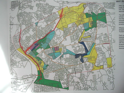
Elementary school "ridership areas," showing where bus-riding kids will come from
4. Boland and Lynch Elementary Schools are experiencing increases in their boundary populations, which is causing school enrollments to exceed their "design capacities." Thus one residential area (RE19) will become associated with Homer Elementary School instead of Boland Elementary School, and another (RE51) will become associated with Glickman Elementary School instead of Lynch Elementary School. "Four street segments that were part of the Lynch proximate zone will become part of the Glickman proximate zone," the report adds.
5. Ongoing sidewalk development in the city is allowing the School Department to continue to convert ridership areas into walking areas without changing the related school assignments. The report adds, "[R]e-zoning is not re-assignment of individual students to new schools—it is the re-association of street addresses with different schools, and those associations are independent of whether or not any current students live at a given street address."
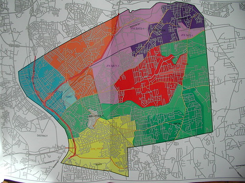
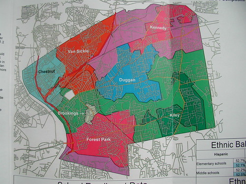
Maps are included in the report, but as it states, "the textual descriptions on the preceding pages are more informative than the maps," which do not show the level of detail such as street names. However, the higher resolution of these maps—which show more detail than the lower-resolution of the maps printed in the newspaper two years ago—do go a long way toward demystifying the geographical aspects of the boundary plan, which to city residents with children, actually matters.
Please speak up if this issue matters to you and if a visual aid would make a difference, as some maps were included in the report.
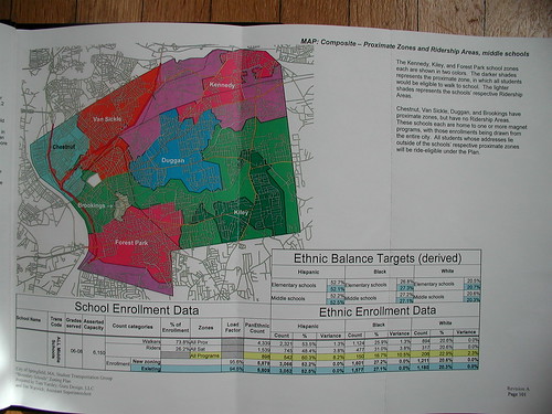 Update: Photos of the maps provided in the report have been uploaded and added here; you can also view them all very large with detailed captions. Of special interest is the small array of tables shown in one image (pictured) detailing some statistics about ethnic balance targets and enrollment data. Also, evidently provided in the report but not in the copy I have is a set of sheets, one for each school, showing its proximate zone and any adjacent and/or satellite ridership areas associated with it. A chart provided (again, not in hand) evidently details the student body makeup by ethnicity for each proximate zone and for each associated ridership area. Seeing such charts would satisfy my own curiosity as to how racially balanced the schools are under the new plan, and in what ways various ethnicities are being drawn upon throughout the city to make each school as balanced as possible.