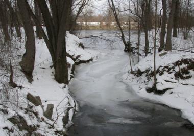
Across the train tracks, underneath an I-91 overpass, and a few hundred yards through the woods, a stream runs from a pile of collapsed masonry into the Connecticut River—the remnants of the first mass transit system to reach the Pioneer Valley.
I've known for a long time that a canal once ran through Northampton, and I also knew that State Street follows the path of the canal built in the early 1800s. What I'd never given much thought to is where that canal went or why it was built.
The Map of the Hampshire & Hampden Canal by Carl E. Walter, available from the Historic Northampton gift shop, answers these questions and renders the importance and enormity of the project in loving detail. For decades, Mr. Walter has walked the length of the canal, rediscovering its path, and his publication is the result of those first-hand discoveries and the careful piecing together of old geological survey maps.
*
Northampton was the northern terminus for two connected canals that stretched for nearly a hundred miles south to New Haven, Conn. and were in operation for more than a decade (1835?1847). The northern part of the canal (which Mr. Walter's map covers) was called the Hampshire and Hampden Canal, and the southern was the Farmington Canal.
The project's genesis was as New Haven's gambit to trump rival Hartford's control over inland commerce. Hartford was (and is) situated at the northernmost point where sloops from the Long Island Sound could dock, making it both a seaport and a city with access to the inland resources and markets. At the time, Walter writes, "land transportation was so difficult that it cost a New Haven merchant as much to transport a ton of goods thirty-three miles by road to Farmington, Conn. as it did to make the same shipment by sea to London, England."
With the recent success of the Erie Canal for transporting goods between New York City and the Great Lakes, a canal between New Haven and Northampton was seen as a boon for both these cities and all those along its course. Such a canal would fundamentally change the inland economies, and the initial enthusiasm and financial support behind the project were strong.
The advantage of a canal over the Connecticut River as a thoroughfare was that the canal was engineered not to have a current that barges would need to struggle against in one direction. With a still canal, barges could be pulled along by horses or people from an adjacent tow path just as easily in either direction.
While I'd understood this basic concept, I had not understood the enormous difficulty in maintaining a 25-foot-wide, four-foot-deep canal of still water over the course of nearly a hundred miles. Mr. Walter's in-depth notes about canal construction outline the challenge in great detail. The designers needed the canal's path to work with the available water sources both to feed the canals when the levels dropped and to release water when there was flooding. Much of the canal's path runs near rivers and swamps (indeed, it ran right through the marsh area adjacent to Northampton's Stop and Shop, and the path can be seen clearly in Google Earth), but there were several places where feeder canals were built for miles off the main route to hook up with a distant lake or river.
Obviously, too, the path between Northampton and New Haven was not completely flat, and in order to maintain the current-less water passage, a series of 32 locks were built to raise and lower barges. Similarly, the path often crossed other streams and important passages. Culverts needed to be built to let water pass under the canal bed, and aqueducts were raised when the canal had to pass over a road or waterway.
Even with all this engineering in place, though, few years went by where the canal could be used all year long. In the winter frozen canals were not passable, and a summer drought could have the same result. Beaver and muskrat tunnels undermined the integrity of some of the canal banks, and when they were breached, millions and millions of gallons of water would hemorrhage out into a farmer's fields.
Many landowners affected by the canal's path were resentful, and vandalism was also a constant issue.
For the 10 years it was in service, there is no question that the canal fundamentally improved the economies of Western Massachusetts, bringing not only revenue and merchandise but culture and new ideas to the Valley. Even so, the canal was a financial failure for its investors. Many of the canal beds and tow paths were turned into railroad lines, and soon trains usurped the usefulness of the waterway.
One of the most exciting aspects of Carl Walter's map is that it not only shows the approximate path of the canal (an original map has never been found), but it also indicates where traces of the canal can still be seen. Much to my surprise, I found that the canal used to pass not far from my front door; it was even more illuminating when I learned that many old, overgrown paths I walk along or drive by on my way to work in Easthampton were not old railroad beds, but the canal itself. In the weeks since I first got the map, I've been able to follow much of the route from where it connected to the Connecticut River (see photo) all the way down to Southampton.
Following the canal's path, learning how it was built, and understanding its effect on the area where I live has made me consider the absence of such vision and industry in the Pioneer Valley today. Instead of broadening our sense of what's possible, the phenomenal advancements in technology seem to have had the opposite effect. Facing now what seems to be an inevitable recession and global energy crisis, Greenfield still clamors for a big-box department store to buy cheap underwear, Northampton politicians dream of a new exit ramp off Rte. 91 to service their fantasy conference center, and Hadley considers paving over its wetlands so that more corporations can peddle wares trucked in from thousands of miles away.
Canals may not be the solution for our current economic challenges, but with all signs pointing to the need to end our current fossil fuel-powered transit system before it ends us, the work of those early canal builders offers much more inspiration and hope than the short-term, immediate-gratification schemes of today's elected officials.