New landfill flare.
On September 22, 2008 the Mass. DEP sent to Stantec a Notice of Noncompliance: NON-WE_08_4018 (PDF). Apparently, Stantec signed off on the "complete" installation of the new methane gas flare even though it was not fully installed because there were parts on back-order. When doing so Stantec did not note that the flare was missing parts and the DEP did not realize this until the alarm went off when the flare went out. Stantec was named as the entity in noncompliance.
New ground cover at Northampton landfill
The 2007 addendum to their Hannum Brook water report (PDF) also clarifies that maybe the brook's water is not improving as Stantec had earlier reported.
An October 2008 memorandum from the state's Executive Office of Energy & Environmental Affairs (PDF) also finds on page 2,
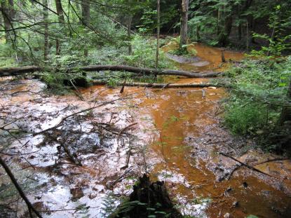
"The Office of Research and Standards disagree with the finding of No Significant Risk of harm to the environment in the Stage 1 Ecological Risk Assessment. As is common downgradient of landfills in the Northeast, there is visible iron flocculent in Hannum Brook and the wetlands south and southeast of the landfill. The flocculent qualifies as Readily Apparent Harm, per 310 CMR 40.0995(3)(b)1. The regulatory definition includes the "visible presence of…non-aqueous phase hazardous material…over an area equal to or greater than 1,000 square feet in sediment within one foot of the sediment surface.
Thus, by regulatory definition, the flocculent covering the sediments in the wetland and Hannum Brook constiutes a risk to the environment. As risk has already been established, a State II Ecological Risk Assessment to determine whether there is significant risk is not required. Given that current site conditions include continued groundwater discharge to these areas, it is likely that any removed flocculent would quickly reform. Therefore continued sampling of groundwater, surface water, and sediments is recommended to monitor the area.
In addition, comparison of surface water quality data to surface water benchmarks does not clearly indicate that the report properly cites current MassDEP surface water benchmarks or that the data do not exceed National Recommended Water Quality Criteria (NRWQC) available at http:www.epa.gov/waterscience/criteria/wqctable/nrwqc-2006.pdf. Surface water quality in exceedance of the NRWQCs wojuld also constitute a significant risk of harm to the environment."

Iron flocculent in Hannum Brook
Finally, paragraph one in an October 2004 letter from the state's Executive Office of Environmental Affairs Western Regional Office (PDF) regarding Maloney Well Zone II Redelineation to former DPW superintendent George Andrikidis and copied to Northampton mayor Mary Clare Higgins and Easthampton mayor Michael Tautznik states,
"As discussed during the technical meeting held this day at the Department's Springfield office with you, Mr. Ned Huntley and your consultants from Dufresne-Henry, Inc. (AKA Stantec) Mr. David Harwood and Mr. James Laurila (currently Northampton's civil engineer), we are forwarding this formal, Technical Deficiency for the permit applications submitted for the redelineation for the maloney Well Zone II. As discussed in detail, based on information presently in the record, the permit applications cannot be fully evaluated. The findings and additional information required by the Department were discussed today and are detailed below."
Pages 4 & 5 in the letter detail the fourteen deficiencies cited and the letter concludes in part,
"The complexity of the hydrogeologic system and the high degree of uncertaintly in the model are not addressed in the report. Specifically, the apparent resultant, unrealistic increase in groundwater elevation heads of the transient model runs is not addressed. The Department's review of a Zone II redelineation, in accordance with the Guidelines, must include more reliable geologic and hydrogeologic information than the current analysis. The Department's conclusions, based on the report as submitted, is that the numerical model is not more reliably accurate than the Conceptual Zone II."
(Above) Movement of leachate plume from Northampton landfill

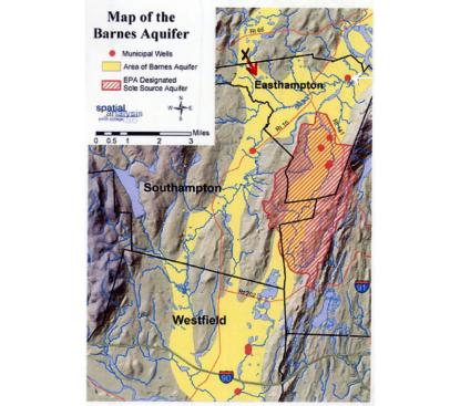
(Above) Map of Barnes Aquifer (landfill denoted as, "X")


