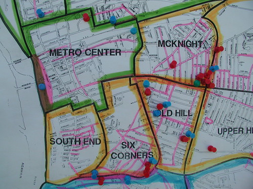
This coming Saturday a massive citywide cleanup effort will take place from 8:30 am to 3:00 pm, organized by Keep Springfield Beautiful, with considerable assistance from many groups, institutions and individuals. At last count, senior project manager Ivette Cruz told me the list of coordinating organizations to thank and appreciate at an upcoming May 9 event has topped 150.
Four staging areas in the city—where people are to gather at 8:30 am and begin the day’s work—correspond with four zones encompassing all the city’s neighborhoods. In the map above, Zone 1 is orange, Zone 2 is green, Zone 3 is yellow, and Zone 4 is blue.
Blue tacks on the map represent numerous "dump sites." Red tacks represent the locations of 32 dumpsters. Of these, the majority will be for regular trash, but four are specific for metal collection, two just for mattresses, and two others just for collecting tires. Ten of the dumpsters are being donated by Joseph Freedman Co., a local scrap metal recycling company.
Four green tacks on the map represent the locations of the staging areas. Pink highlighter pen marks the locations of the 210 or so streets across the city that have been targeted for cleanup, with input from the neighborhood associations.
The zones’ staging areas, corresponding neighborhoods and targeted streets for Saturday are as follows:
 Zone 1
Staging area: Rebecca Johnson Elementary School, 35 Catharine Street (pictured).
Neighborhoods: Upper Hill, Old Hill, Bay, McKnight, Six Corners, South End.
Streets in Zone 1
Upper Hill: Byron Street, Dearborn Street, Dresden Street, Roosevelt Avenue, Wilbraham Road
Old Hill: Eastern Avenue, Orleans Street, Pendleton Avenue, Union Street, Hancock Street
Bay: Bay Street, Hayden Avenue, Oakwood Terrace
McKnight: Buckingham Street, Dorchester Street, St. James Avenue
Six Corners: Brigham Street, Central Street, Clifton Avenue, Hancock Street, Knox Street, Pine Street, Spruce Street, Cedar Street
South End: Central Street, Richelieu Street, Wendell Place
 Zone 2
Staging area: Chestnut Accelerated Middle School, 355 Plainfield Street (pictured).
Neighborhoods: Metro Center, Memorial Square, Brightwood, Liberty Heights, East Springfield.
Streets in Zone 2
Metro Center: East Columbus Avenue, Main Street, Pearl Street, State Street, Worthington Street
Memorial Square: Arch Street, Calhoun Street, East Hooker Street, Greenwich Street, Jefferson Street, Patton Street, Sheldon Street, Church Street
Brightwood: Clyde Street, Demond Avenue, East Fisk Avenue, Hyde Avenue, Newland Street, Orchard Street, Washburn Street, Worcester Avenue
Liberty Heights: Armory Street, Beauchamp Street, Cherrelyn Street, Cunningham Street, Franklin Street, Nursery Street, Warwick Street, Webster Street
East Springfield: Bircham Street, Bowels Park Ext., Campechi Street, Carew Street, Edendale Street, Page Boulevard, Price Street, Stanley Street, St. James Boulevard
 Zone 3
Staging area: Duggan Middle School, 1015 Wilbraham Road (pictured).
Neighborhoods: Pine Point, Boston Road, Indian Orchard, Sixteen Acres.
Streets in Zone 3
Pine Point: Arnold Avenue, Bay Street, Boston Road, Breckwood Boulevard, Crittenden Street, Delaware Street, Breckwood Circle, Grayson Drive, Preston Street, Wilmington Avenue
Boston Road: Grayson Drive, Lamplighter Lane, Methuen Street, Parker Street, Pasco Road, Slater Avenue, Wallace Street, Wisteria Street, Wollaston Street
Indian Orchard: Berkshire Avenue, Center Street, Goodwin Street, Lyons Street, Main Street, Oak Street, Page Boulevard, Pinevale Street, Quebec Street, Water Street, Whipple Street, Worcester Street, River Street, Pasco Road
Sixteen Acres: Bradley Road, North Branch Parkway, Old Farm Road, Plumtree Road, Sunrise Terrace
 Zone 4
Staging area: Forest Park Middle School, 46 Oakland Street (pictured).
Neighborhoods: East Forest Park, Forest Park.
Streets in Zone 4
East Forest Park: Abbott Street, Allen Street, Island Pond Road, Paridon Street, Plumtree Road, South Branch Parkway
Forest Park: Belmont Avenue, Dickinson Street, East Alvord Street, Forest Park Avenue, Fort Pleasant Avenue, Leyfred Terrace, Locust Street, Orange Street, Sumner Avenue, Trafton Road, Washington Street, West Alvord Street, White Street, Woodside Terrace
Mike Cass provided pictures (above) of some of the worst offending sites for cleanup, what he has come to call the "baker’s dozen." These were on display at the Keep Springfield Beautiful table during Sunday’s Earth Day festival at the Quad, and a sampling of them was also published here last week.
Cass will visit these sites on Saturday along with a troupe of around 60 inmates from the Hampden County Correctional Center to do cleanup work. Barring complications, I will accompany them as well to document the ordeal, and see just how bad these worst-offending sites really are, and what goes into purging them of junk.
Springfield is competing with 600 other Keep America Beautiful affiliates on various measurable factors related to cleanup efforts: tons of trash removed, square footage of graffiti removed, beautification, and public service announcements. Keep America Beautiful maintains a community toolbox that shows how these factors can be measured. The toolbox also features additional resources and best practices in other US cities.
If you’re out doing cleanup work somewhere in Springfield on Saturday, and you have a camera, please send photos my way and I’ll publish them here.
And if you can’t offer assistance in the form of physical labor on Saturday, consider a tax-deductible contribution to KSB. Send a check to 1600 East Columbus Avenue, Springfield MA 01103. With questions contact senior project manager Ivette Cruz at (413) 886-5044 or icruz@springfieldcityhall.com.


